
Aligned with the UK Environment Bill (2021) which mandates a net gain for nature, we have worked with Natural Capital Solutions to deliver a set of underpinning map models for informed local implementation of the Lawton Principles of Bigger, Better and more Joined. The opportunity mapping service is key to local implementation of Northamptonshire’s Nature Recovery Network as developed by Natural Capital Solutions with the support of the Natural Capital Investment Group (North Northamptonshire Council, West Northamptonshire Council, Peterborough Council, River Nene Regional Parks, Wildlife Trust for Bedfordshire, Cambridgeshire and Northamptonshire, Natural England, Environment Agency, and ourselves the Northamptonshire Biodiversity Record Centre). The methodologies used to produce the Natural Capital Maps are broadly explained in; Habitat opportunity mapping in Northamptonshire and Peterborough, May 2018. The supplied Natural Capital Maps go further than in this report and use the most up to date data available.
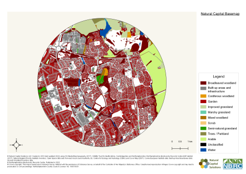
The Northamptonshire Biodiversity Record Centre are host to the most up to date and detailed resolution of Natural Capital Habitat Opportunity Maps. There are 26 map layers available which detail for the whole county, a best approximation of Northamptonshire’s existing Natural Capital in the Basemap, the Ecosystem Services provided by these natural resources, demand for these natural services and opportunities for their enhancement, and the opportunities for habitat protection, restoration and creation to enhance connectivity for biodiversity net gain. The maps are indicative models, based on the most up to date information possible at the time of modelling (last done in 2021) including:
- Natural Capital Base Map: Detailed assessment of current natural capital assets. The best approximation of existing habitat types present across the area based on available data.
- Constraints Map
- Combined Opportunities Maps
- Ecosystem Services Maps
- Habitat Opportunities Maps

Through this service, the maps are available as a full set of pdf maps, together with the accompanying User Guide. We advise professional ecological support in using the maps in any habitat improvement, connectivity planning and new creation. These maps can be provided at the level of parish boundary (£235+VAT) or as a bespoke search around a supplied grid reference/site with a minimum 2km2 buffer (£275 +VAT). The Natural Capital modelled maps are only supplied as additional to a standard data report with a minimum 2km2 buffer applied (where the Habitat Opportunity Maps are requested BAP habitat maps are provided at no extra charge). The models are based on the best available data at the point of remodelling (2021) and should be used alongside the supplied current sites, species and habitat information provided. Charges are based on fair non-profit principles, as with other Northamptonshire Biodiversity Record Centre services. The charges are made to cover the costs of administering the service; for ongoing improvement of base habitat information and accuracy of the base mapping; and to periodically update the models and maps.
We welcome feedback from users of the maps and hope to build an increasing list of case studies of local implementation and good practice projects to list on this page. All biological recording, commissioned survey and ecological reporting to the record centre is encouraged. We would also welcome local feedback on the natural capital basemap and rights of way for incorporation in the next round of remodelling. Please contact us: nbrc@northantsbrc.org.uk
Useful Links and Resources
Natural Capital
Habitat Opportunity Mapping in Northamptonshire and Peterborough
Mapping Natural Capital and Ecosystem Services in the Nene Valley
Government publication: Enabling a Natural Capital Approach guidance
Nature Recovery Networks
Government publication: Nature Recovery Network
Wildlife Trust BCN Nature Recovery Network Mapping
Wildlife Trusts Nature Recovery Network Handbook
Research and Best Practice
Forest Research: NFI Woodland Ecological Condition
Alliance for Scotland’s Rainforest: Best Practice (savingscotlandsrainforest.org.uk)