
The NBRC commercially licenced drone pilots have been delivering projects to inform ecological planning and monitoring since 2018 thanks to funding support by the Environment Agency. Our Phantom 4 Pro professional UAV drone, affectionately known as Eristalis tenax (E.T. for short) is capable of capturing HD video and aerial imagery taken from up to 400ft altitude. A typical survey would be completed from 300ft and deliver whole site detail in just 20 minutes of flight time, with repeat visits it is an effective tool for habitat management planning, monitoring and evidencing change as highlighted in recent practical guidance for biodiversity net gain by CIEEM.
The drone is well equipped to produce imagery and footage in stunning detail to meet the needs for a range of projects, with an on-board 20-megapixel camera capable of Burst Mode stills at 14fps due to a custom engineered lens and mechanical shutter. The camera is equipped with powerful video processing providing high definition 4K/60fps video. Flights can be programmed for close up, 3D and whole site imagery.
Drones are increasingly being used as a tool for planning, monitoring and evidencing change, be it site developments, habitat restoration work or for species counts. With this new technology we can image whole areas, giving an accurate point in time picture and reducing the risks associated with ‘on the ground’ survey.
With the use of image stitching software we are able to produce both panoramic and orthomosaic imagery, this delivers whole site birds-eye views of sites with high definition detail. Aerial footage can show in close up detail areas of your site it would be hard to access on foot as well as delivering footage that showcases your site. As GIS specialists, we can also deliver images as geolocated flat GIS layers and complete habitat mapping project work, identifying the extent of vegetation by broad type. There are an ever-increasing application of drone and aerial imagery in species monitoring, site planning and habitat management.
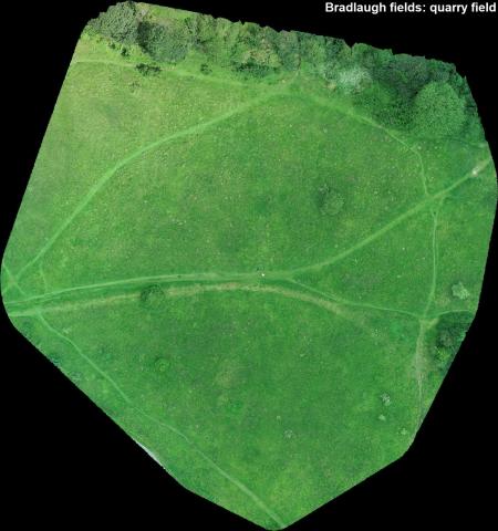
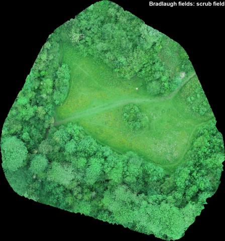
Case Study – Wildlife Trust Reserve Manager for Bradlaugh Quarry and Scrub (surveyed 2019)
What area/habitat/issue were you aiming to capture through aerial photography?
For Bradlaugh specifically it was the extent of scrub cover and thickness of hedges. The three scrub fields are important for flowering plants and we don’t want to slowly lose them to encroaching scrub.
Aerial views, especially if we have them a couple of years apart, will allow us to see changes in vegetation cover – e.g. scrub spreading or being knocked back, extent of reed bed size and loss to willow, amount of fringing vegetation alongside lakes.
What benefits did the drone offer over traditional methods?
It’s nigh-on-impossible to gauge hedge thickness from ground level, aerial shots are much better! I am interested in the use of 3D modelling that I’ve seen for other sites in future surveys.
What other applications for your work would you envisage use of the drone could be beneficial for?
Several; blackthorn flowering, wild cherry flowering, herons nesting and birds nesting in islands in lakes, for example.
Our operators are fully trained, commercially licenced and insured to fly; please complete the Drone service booking form and send to nbrc@northantsbrc.org.uk to discuss booking the team for your aerial photography and footage needs.
A typical survey booking of a small site is a minimum of a day; with pre-flight planning and assurance of relevant aviation permissions, travel to/from site, safety set up by our CAA licenced pilot and aerial survey to collect the agreed raw imagery for digital delivery. The raw images for a 3600 panorama can be taken swiftly on site and ‘stitched’ in post production. The raw images for a whole site orthomosaic (birds eye view) from 300ft would take around 20 minutes of flight time, with additional ‘stitch’ post production for a single image. With enough time we can capture footage and your site in 3D. With repeat visits, and particularly where seasonally timed, drone use is an effective tool for habitat management planning, monitoring and evidencing change as highlighted in recent practical guidance for biodiversity net gain by CIEEM.
This service is chargeable at a rate of £65 +VAT per hour, with a minimum booking of 5 hours to include pre-flight assessment, drone survey and supply of the raw imagery. Please indicate your needs on the booking form and we will provide you with a quote based on site size, time needed for the requested image/footage capture and your post-production requirements for imagery and film. Travel over a 15-mile radius of our Lings Office is charged at 40p per mile. Please note timing of bookings are weather dependant and we will require written permissions from landowners provided before commencement of pre-flight planning. Please discuss with us your full project needs and note that we offer a discount where booking drone monitoring time in bulk.